Switching the screens
Any one of the screen configurations can be selected.
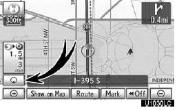
1. Touch this button to display the following screen.
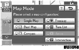
2. To select the desired screen configuration, touch one of the following buttons.
Depending on the conditions, certain screen configuration buttons cannot be selected.
 To display the single map screen.
 To display the dual map screen.
 To display the compass mode screen.
 To display the freeway screen.
 To display the turn list screen.
 To display the arrow screen.
 To display the intersection guidance
screen or the guidance screen on the freeway.
To display the intersection guidance
screen or the guidance screen on the freeway.
Screen configurations
SINGLE MAP
This is a regular map screen.
While on a different screen, touching
will display the single map screen.
The screen shows the single map.
A map can be displayed split in two.
While on a different screen, touching
will display the dual map screen.
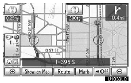
The screen shows the dual map. The map on the left is the main map.
The right side map can be edited by touching any specific point on the right side map.
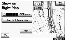
This screen can perform the following procedures:
1. Changing the map scale
2.Displaying the POI icon
3.Show XM NavTraffic Info.
4.Changing the orientation of the map
Touch ÔÇťOKÔÇŁ when you complete editing.
The screen returns to the dual map screen.
COMPASS MODE
Current vehicle position is indicated with a compass.
While on a different screen, touching
 will display the compass mode screen.
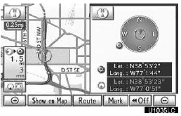
Information about the destination and current position, as well as a compass, is displayed on the screen.
The destination mark is displayed in the direction of the destination. When driving refer to the longitude and latitude coordinates, and the compass, to make sure that your vehicle is headed in the direction of the destination.
INFORMATION
When the vehicle travels out of the coverage area, the guidance screen changes to the compass mode screen.
See also:
Fast-forwarding and rewinding songs
To fast-forward or rewind, press and hold ÔÇťÔÇŁ
or ÔÇťÔÇŁ on the ÔÇťSEEKÔÇóTRACKÔÇŁ button until
you hear a beep. ...
Clock settings
Used for changing time zones and the on/off settings of daylight saving time.
1. Push the ÔÇťSETUPÔÇŁ button.
2. Touch ÔÇťClockÔÇŁ.
3. Touch the items to be set.
4. Touch ÔÇťSaveÔÇŁ.
SCREEN ...
If the engine does not start
Make sure that the correct operating procedures have been followed.
Make sure that the brake pedal is firmly
depressed when attempting to start the engine.
Make sure that the steering lock ...